At this point, we had a decision to make: continue farther along the TransCan or detour up the Avalon Peninsula between Trinity Bay and Conception Bay. With names such as Dildo Cove and Heart's Desire, we could not resist the temptation to travel yet another north-reaching finger of land. (Don't believe I just wrote that.)
After searching endlessly for a breakfast place, we drove on the TransCan until we found a truck stop with a restaurant. Picking up our route again on Hwy 80, we stopped at Heart's Content to view the cable station, site of a major relay station point for transatlantic telegraph messages and the place where the first transatlantic cable landed in 1866.
We don't always join a tour group at museums, prefering to move along at our own pace. This museum tour proved to be quite informative, not so much about the cable industry, but the lives of the people of Heart's Content during the height of the cable business. Originating in the British Isles, the business brought employees from England to operate the machines (the building still houses original equipment). A community of ex-pats developed apart from the local community: churches, schools, clubs, etc. It cost $5.00 to send a child to their school and the local fisherman could not afford to pay the tuition. Almost all the operators were imported with the exception of one notable Newfoundlander and his name is remembered by locals to this day, but I can't remember it. Also noted is the fact that during times of war, women were used as operators and proved to be faster and more accurate than men.
At Heart's Desire Lighthouse we searched for yet another geocache, but came up empty-handed.
Because John Cabot told the world about the abundant codfish in the area, an influx of fishermen from Europe began to fish the area seasonally and then began to settle permanently. At the tip of the peninsula sits Grates Cove where evidence of its Irish past still remains - rock fencing on hillsides.
Driving back down Hwy 70, along the pirate coast, we traveled through several small communities and settled for the night at Brigus' Crow Rock Camp, a brand new campground whose dust had yet to settle.
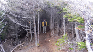
At Harbour Grace, we followed our noses to get a better view of an iceberg just offshore. Parking the van along the road, we hiked across a stretch of tuckamore. Back in Harbour Grace, an airplane and an Amelia Earheart statue commenorate her transatlantic flight which began here in 1932. Aground in the harbor is the SS Kyle, a former cargo/passenger vessel which worked up and down the coast. Grass now carpets the decks.....
At Cupid, we stopped to tour the Legacy Centre and met the manager leaving for home on a bright Sunday morning. He was most interested in telling us about his childhood growing up in Cupid. Precious little commercial fishing operates out of Cupid today, but most residents are descendents of those intrepid fishermen who came to carve out a living on this most fertile, yet unforgiving coastline. The three fishermen who still ply the trade fish with longlines for crab and shrimp. The Legacy Centre was built not as a museum, but as a reminder of where they came from. Most of his school friends have left for various parts of the world, but still consider this their home.
Not far from the centre is an archelogical dig, site of a colony during the 1600's. So far over 100,000 artifacts have been found. Pre-dating Jamestown in Virginia, the findings suggest a well-organized and successful colony.
...cruising through retirement aboard S/V Beowulf, M/S Sandpiper and our "land yacht" Shorebird, a 210 Versatile Roadtrek.
Showing posts with label icebergs. Show all posts
Showing posts with label icebergs. Show all posts
Friday, January 25, 2013
Friday, September 7, 2012
Newfoundland7
We weren't the only ones to search for a better view of the iceberg. Several tour buses were tentatively negotiating the narrow, winding roads to capture that perfect shot. No wonder folks were excited: last year not one iceberg showed up until September. We had arrived at the perfect time to see icebergs. There had been two weeks of prolonged northeast winds pushing them in our direction.
On the way into town, we noticed several signs selling lobster; there were few if any on the western coast. We made our way through town and toward Peyton's Woods RV Campground. We had the pick of sites so we chose one closer to the road with a clear view of Back Harbour. Rocky and hilly, we had our choice of footpaths and trails to follow. We picked ourselves up and walked on over to Back Harbour.
Footpaths, used by many generations, abound and for good reason. If you are a fisherman and want to know what the seas are like, it is much more efficient to hike up the path to the top of the hill and look than to take your small boat out and find out the hard way.
Back at our campsite it was time to eat the lobster we bought in Labrador. Our Roadtrek has a very good freezer unit in the refrigerator, so our lobster was still in good condition.
The next morning we followed a trail into the nearby woods to find a geocache. Just off the path in an area that was rocky and moss-covered, the geocache was well-hidden; but we found it with a little bit of walking in circles. The trees affect the GPS's ability to get a good fix, but the Garmin 62st does the best job of it than any of my other GPS's.
We still had time to kill before our afternoon cruise to the iceberg, so we explored the area around Long Point Lighthouse. There are two geocaches in the area, but we did not have time to do the hikes and still make our boat. Instead, we walked the trail up to The Pinnacle. We parked the Roadtrek at the bottom of the hill in an area that looks to be an old fishing harbor, but is being used now for a playground and picnic area.
Long Point Lighthouse sits on top of one of the steepest and most imposing shorelines I have ever seen. Trails crisscross the landscape with signs warning of the treacherous paths ahead and down.
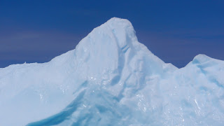
Taking the tour boat out to the iceberg was well-worth the time and expense. Just seeing a piece of ice 10,000 years old so close that I could see the intimate curves, the plastic-like surface glistening in the sun. I wanted to pat it, to speak to it, absorb it. See for yourselves.
The captain drove all the way around twice before he had to head back for his next cruise. Even though the winds were fairly light, motoring out the cove and around to Twillingate was a bit rolly, another way of saying we had 6-8 foot swells crashing into the rocks
Subscribe to:
Comments (Atom)


