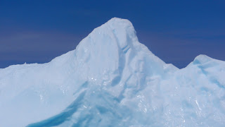
We weren't the only ones to search for a better view of the iceberg. Several tour buses were tentatively negotiating the narrow, winding roads to capture that perfect shot. No wonder folks were excited: last year not one iceberg showed up until September. We had arrived at the perfect time to see icebergs. There had been two weeks of prolonged northeast winds pushing them in our direction.
On the way into town, we noticed several signs selling lobster; there were few if any on the western coast. We made our way through town and toward Peyton's Woods RV Campground. We had the pick of sites so we chose one closer to the road with a clear view of Back Harbour. Rocky and hilly, we had our choice of footpaths and trails to follow. We picked ourselves up and walked on over to Back Harbour.
Footpaths, used by many generations, abound and for good reason. If you are a fisherman and want to know what the seas are like, it is much more efficient to hike up the path to the top of the hill and look than to take your small boat out and find out the hard way.
Back at our campsite it was time to eat the lobster we bought in Labrador. Our Roadtrek has a very good freezer unit in the refrigerator, so our lobster was still in good condition.
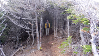
The next morning we followed a trail into the nearby woods to find a geocache. Just off the path in an area that was rocky and moss-covered, the geocache was well-hidden; but we found it with a little bit of walking in circles. The trees affect the GPS's ability to get a good fix, but the Garmin 62st does the best job of it than any of my other GPS's.
We still had time to kill before our afternoon cruise to the iceberg, so we explored the area around Long Point Lighthouse. There are two geocaches in the area, but we did not have time to do the hikes and still make our boat. Instead, we walked the trail up to The Pinnacle. We parked the Roadtrek at the bottom of the hill in an area that looks to be an old fishing harbor, but is being used now for a playground and picnic area.
Long Point Lighthouse sits on top of one of the steepest and most imposing shorelines I have ever seen. Trails crisscross the landscape with signs warning of the treacherous paths ahead and down.
Taking the tour boat out to the iceberg was well-worth the time and expense. Just seeing a piece of ice 10,000 years old so close that I could see the intimate curves, the plastic-like surface glistening in the sun. I wanted to pat it, to speak to it, absorb it. See for yourselves.
The captain drove all the way around twice before he had to head back for his next cruise. Even though the winds were fairly light, motoring out the cove and around to Twillingate was a bit rolly, another way of saying we had 6-8 foot swells crashing into the rocks
...cruising through retirement aboard S/V Beowulf, M/S Sandpiper and our "land yacht" Shorebird, a 210 Versatile Roadtrek.
Showing posts with label Twillingate. Show all posts
Showing posts with label Twillingate. Show all posts
Friday, September 7, 2012
Monday, September 3, 2012
Newfoundland6
Knowing we had to backtrack in order to pick up the TransCan, we detoured off of Hwy 430 and took Hwy 432 to Plum Point instead. It gave us a good view of the interior of the Northern Peninsula, thickly forested with Douglas Fir and White Pine. Along the way, we spotted several garden plots. Newfoundland is so rocky that residents search out a narrow space along the road with fertile soil and plant a garden. We were there in June, a bit like April in Indiana, so gardens were being turned (by hand) and row hills were established for root crops.
Along with the garden plots, there were many log "yards". Some contained piles of split logs while others were neatly stacked in rows. We assumed that snowmobiles pulling wooden sleds were used to haul the timber back near the road for cutting.
The long stretch of highway apparently didn't hold Missy Moo's interest, so a little vocabulary lesson might be in order:
Tuckamore - most of the hikes we have taken in search of geocaches have taken us across an area called tuckamore, an area of low-lying bushes and trees,often twisted and stunted by the constant winds. Tuckamore contains many plants that produce edible berries important to thousands of migratory birds and a staple in every larder such as bakeapple, partridgeberry, wild blueberry, squashberry and crowberry.
Tickle - A tickle is a narrow salt-water strait as an entrance to a harbor, considered treacherous because of its narrrowness and/or the tides.
It was almost a two-day trip back down the Northern Peninsula and then taking the TransCan until we came to Hwy 340 which would take us to Twillingate. Even though we were determined to explore every peninsula, we did bypass Baie Verte Peninsula. We could, however, add two moose and one coyote to our animal count.
Just before arriving in Twillingate, we spotted a large iceberg in a cove to our right. We turned around and took a road in that direction in hopes of seeing it close by, but the road ended in a cluster of homes and the rocky hills blocked our view. After crossing a bridge, we turned right again and did find ourselves across from the iceberg, but still not as close as we wanted. Driving through Twillingate, we took note of several tour companies offering whale watching and iceberg viewing. The next day we hoped to see that iceberg up close. The fun was just beginning.
Along with the garden plots, there were many log "yards". Some contained piles of split logs while others were neatly stacked in rows. We assumed that snowmobiles pulling wooden sleds were used to haul the timber back near the road for cutting.
The long stretch of highway apparently didn't hold Missy Moo's interest, so a little vocabulary lesson might be in order:
Tuckamore - most of the hikes we have taken in search of geocaches have taken us across an area called tuckamore, an area of low-lying bushes and trees,often twisted and stunted by the constant winds. Tuckamore contains many plants that produce edible berries important to thousands of migratory birds and a staple in every larder such as bakeapple, partridgeberry, wild blueberry, squashberry and crowberry.
Tickle - A tickle is a narrow salt-water strait as an entrance to a harbor, considered treacherous because of its narrrowness and/or the tides.
Just before arriving in Twillingate, we spotted a large iceberg in a cove to our right. We turned around and took a road in that direction in hopes of seeing it close by, but the road ended in a cluster of homes and the rocky hills blocked our view. After crossing a bridge, we turned right again and did find ourselves across from the iceberg, but still not as close as we wanted. Driving through Twillingate, we took note of several tour companies offering whale watching and iceberg viewing. The next day we hoped to see that iceberg up close. The fun was just beginning.
Labels:
iceberg,
roadside gardens,
tickle,
tuckamore,
Twillingate
Subscribe to:
Comments (Atom)


